How to Read a Property Plat Map
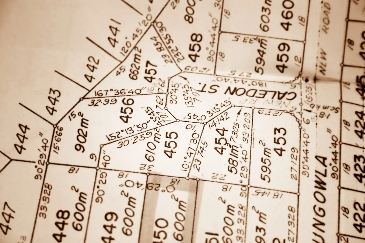
Table of Contents
- How to Read a Property Plat Map
- Plat Map Definition
- Plat Map vs. Survey: What’s the Difference?
- Example of a Plat Map and How to Read It
- Lot and Block Numbers
- Property Lines
- Subdivision Information
- Road Names & Easements
- Recreation or Common Areas
- FAQs
- What is a plot map, and is it the same as a plat map?
- Is a plat map the same as a survey?
- Does a plat map show exact boundary lines?
- What does a plat map usually not show?
- Where can I find a plat map for my property?
When buying a home, it is important to know exactly what you’re paying for. In many situations, boundary lines become muddied between neighbors. Maybe someone built their fence too far out, or they planted a different type of grass that grew into the other person’s lawn.
These physical indicators may cause each property to appear larger or smaller than official records say. Buyers and sellers must review property records before closing to confirm the property’s precise dimensions.
Plat maps are not the most readable documents. However, these maps are helpful visual guides that show how land is divided within a neighborhood.
Plat Map Definition
Plat maps are like a property line map. They are diagrams that show how a developer subdivides land into lots or public-access locations. These maps are created by surveyors and civil engineers, and submitted to the relevant county’s planning department.
A plat map provides a more visual representation of land than purely written legal descriptions. The map shows how lots are arranged, each lot’s dimensions, how they connect to roads, and planned easements.
Title insurance companies and lenders review plat maps to ensure the seller is accurately representing the property. Some sellers do not know their property’s real size, leading to inaccurate descriptions on closing documents.
Not all properties have a plat map. Only subdivided properties with lot numbers have been platted. Many deeds use metes-and-bounds descriptions and maps, instead.
Plat maps are commonly used in several places, including:
- County Land Records: Counties keep official plat maps as part of the public record
- Title Documentation: Plat maps are often referenced in legal descriptions
- Permitting and Construction: Plat maps help show how big a renovation should be or how construction will affect the neighborhood as a whole
Plat Map vs. Survey: What’s the Difference?
Surveys and plat maps are similar concepts, but not the same. Both depict tracts of land, detailing boundary lines and property dimensions. They both also provide locational information, such as the county, connected streets, and lot.
However, a survey also displays improvements on the property that are not included in a plat map, such as driveways, pools, and dwellings. These additional details stem from the fact that surveys are often performed for individual lots rather than for a subdivision, such as a plat.
Plat maps are required for development approval. Developers create these property line maps to inform the county of their plans to split the land. The county needs this information because it affects factors such as addresses, city planning, and mail delivery.
In contrast, surveys are typically performed for individual use. The owner may want to use a survey to settle a boundary dispute or to confirm the land's size before a sale.
Example of a Plat Map and How to Read It
Plat maps look like a collection of rectangles and random numbers, but each element provides essential information. Interested parties can find a plat map at their county’s zoning office or through a city planner.
Some jurisdictions also maintain an online GIS (Geographic Information System). These services can be searched by address, allowing users to hover over a property for its information. However, you may have a physical or scanned property line map. So, let’s cover the various parts and what they mean.
Lot and Block Numbers
Each subdivision contains various blocks, which are further split into rectangular lots. Block numbers are often written in bold and overlap multiple lots. Lot numbers are written in the center of the lot in smaller text.
Note: Lots may also include an underlined number. This number refers to the Assessor’s Parcel Number. The actual lot number will not be underlined.
Property Lines
The outlines around each lot are the boundary lines of individual parcels. These boundary lines have one or more numbers written along their length. Numbers inside the line indicate the boundary line’s length in feet.
Boundary lines perpendicular to the street may not have a listed number. This is because all the parcels in that row have the same length, so the measurement is only listed once.
There may be another number written outside the parcel, in the street. This number is the property’s house or building address number. Not all plat maps include this number.
Subdivision Information
Many plat maps include the subdivision’s name, such as Oakwood Creek Subdivision or St. Bernardino Subdivision. There may also be an underlying paragraph that describes the subdivisions, purpose, and size.
Road Names & Easements
Plat maps usually label nearby streets, cul-de-sacs, and access roads. This helps identify which lots face specific streets and how traffic flows through the development. Some maps may also show easements surrounding the lots, which typically represent a shared alley or driveway.
Recreation or Common Areas
Many subdivisions are earmarked as residential communities. So, large spaces are labeled as “common areas,” such as parks, playgrounds, sports fields, or trails. You may also see the term “Greenbelt,” which refers to undeveloped land in the subdivision.
A property plat map might look complicated at first, but it is something every homeowner should familiarize themselves with. This map shows how land is divided within a subdivision, allowing you to quickly resolve boundary disputes or determine how far you can build a renovation.
Whether you’re buying a home, researching property records, or confirming boundaries, learning how to read a plat map can help you better understand how a property fits into the surrounding area.
FAQs
What is a plot map, and is it the same as a plat map?
A plat map displays the boundary lines, size, and location of all the lots within a subdivision. In contrast, a plot map hones in on one property within that area, including information like landscaping features or fence locations.
Is a plat map the same as a survey?
No, plat maps are not the same as geographical surveys. A survey is most often used for personal use, rather than as a procedural requirement for developing a subdivision. Surveys also typically cover one property, especially when ordered for residential areas.
Does a plat map show exact boundary lines?
Yes, civil engineers measure a plat map’s boundary lines to the hundredths decimal place. This information allows homeowners to precisely determine where their property begins and ends.
What does a plat map usually not show?
Plat maps are primarily property line maps. They do not regularly show buildings, fences, or other renovations such as pools. However, some subdivisions include information on communal amenities like pools, sports courts, parks, and trails.
Where can I find a plat map for my property?
Plat maps are typically available through county recorder offices, assessor offices, title documents, or local property record databases.

Elena Novak leads real estate research and analysis at PropertyChecker.com, where she digs into housing trends, tracks property data, and unpacks investment strategies across the U.S. With a background in flipping homes and a degree in Business and Real Estate Development, she brings a practical, hands-on approach to market analysis. Elena is especially skilled at uncovering hidden property value and guiding both homeowners and investors through shifting market conditions. She's also passionate about sustainable design and smart home innovation. When she's not analyzing the market, she's probably knee-deep in a DIY project, scouting vintage décor, or building something new in her workshop.
Search Property & Deed Records
Table of Contents
- How to Read a Property Plat Map
- Plat Map Definition
- Plat Map vs. Survey: What’s the Difference?
- Example of a Plat Map and How to Read It
- Lot and Block Numbers
- Property Lines
- Subdivision Information
- Road Names & Easements
- Recreation or Common Areas
- FAQs
- What is a plot map, and is it the same as a plat map?
- Is a plat map the same as a survey?
- Does a plat map show exact boundary lines?
- What does a plat map usually not show?
- Where can I find a plat map for my property?