What Is a Parcel Map and What Can It Tell You About Your Property?

Table of Contents
- What Is a Parcel Map and What Can It Tell You About Your Property?
- What Is a Parcel Map?
- Parcel Map vs. Plat Map vs. Survey
- How to Access Parcel Maps Online
- How to Read Parcel Maps to Understand Property Boundaries
- How Parcel Maps Reveal Property Value Factors
- Common Red Flags to Watch For
- FAQs about Parcel Maps
- What Is the Difference Between a Parcel Map and a Survey?
- Can I Rely on a Parcel Map for Legal Property Boundaries?
- Do Parcel Maps Show Easements or Flood Zones?
- What If the Parcel Map and My Fence Line Don’t Match?
- Do Parcel Maps Affect Property Taxes or Value?
When you're buying a home, planning a renovation, or just curious about your own property, it's easy to focus solely on the house. But the land it sits on is just as important. Parcel maps are one of the most useful (and underused!) tools available to help you understand your property. They clearly show its shape, size, and boundaries and can reveal critical details about access, easements, zoning, and potential issues that could affect its value.
We'll demystify parcel maps by explaining what they are, where to find them, and how to read them like a pro. If you’ve ever tried to figure out precisely where your property starts and ends, this article is for you. You don't need to be a surveyor or real estate expert; you just need to know where to look and what to look for. Let's help you master this essential piece of property research.
What Is a Parcel Map?
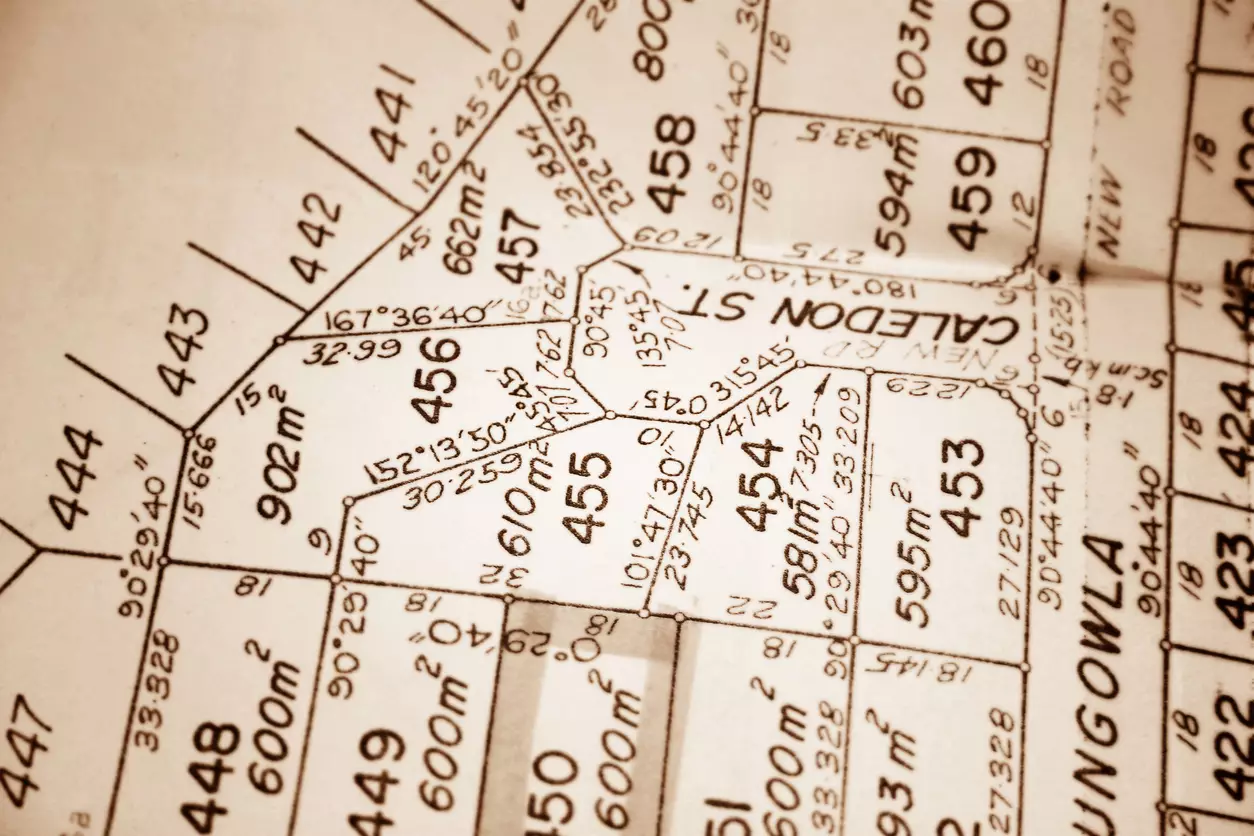
A parcel map is a digital or printed map that shows how land in an area is legally divided into individual pieces, commonly called “parcels” or “lots.” They typically display property boundary lines, the parcel’s shape and size, the location of structures, neighboring parcel locations, and other key features like easements, rights-of-way or shared access paths, and zoning districts. Each parcel identified on the map is also assigned a unique identification number (APN, PIN, or Parcel ID).
Parcel maps are usually created and maintained by local governments (typically a county assessor’s office or land records department) and are often available for free through public GIS (Geographic Information System) portals. These maps are primarily used by county assessors to value property for tax collection. They are also regularly used by homeowners, buyers, investors, real estate agents, surveyors, planners, developers, and lenders for ownership and zoning verification, land use planning, and legal documentation.
Parcel Map vs. Plat Map vs. Survey
Parcel maps, plat maps, and surveys are all tools used for determining property boundaries, making it easy to confuse them. However, they each serve different purposes:
- Parcel Map: This shows boundary outlines, parcel locations, and parcel numbers. Parcel maps are mainly used for administrative (basic research, property lookup, zoning checks) and taxation purposes and are a great tool for getting a general overview of your property and identifying potential issues. However, they are not “legally” precise for determining the exact location of your boundary line.
- Plat Map: This is a detailed map of a subdivision, showing how a large piece of land is divided into individual lots, streets, and public areas. It is more formal than a general parcel map and is often used in planning and development.
- Survey: Surveys are legally binding documents that outline the precise measurements and legal boundary descriptions of a specific property. A survey is what you need for building a fence, settling a dispute, or during a real estate transaction.
Basically, parcel maps are great for general reference, but surveys are the legal authority when it comes to exact boundaries: if a parcel map is a road atlas giving you a general layout, a survey is the GPS telling you your exact location down to the inch.
How to Access Parcel Maps Online
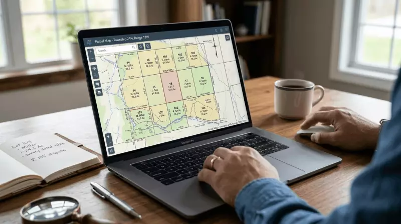
Most counties and cities offer free access to parcel maps through their GIS or assessor websites. You don’t need technical skills or special software to access these maps, just an address or parcel ID number. Here’s how:
- Go to Your County Assessor or GIS Mapping Website: Search online for “[county name] assessor parcel map,” “[county name] GIS parcel search,” “[county name] property lookup,” or “[county name] parcel viewer.” The correct link will usually be from a government domain (e.g., “.gov” or “.us”).
- Locate the Search Tool: Once on the site, look for a clearly labeled "Property Search," "Parcel Viewer," or "Map Search" tool. It's usually prominently displayed on the main page.
- Search by Address or Parcel Number: Enter the property’s street address or parcel number/ID (if you have it). Some counties may also allow lookups using additional parameters, like owner name and tax ID.
- Explore the Map: Zoom in to see lot lines, dimensions, and neighboring parcels. Click on a parcel to view details like zoning, acreage, tax info, assessed value, and legal description. You can also explore the map layer options: many GIS tools let you toggle overlays for features like flood zones, easements, zoning districts, utilities, etc. Check different options to uncover all available details.
- Download or Print the Parcel Map if Needed: Most portals allow exporting a PDF or saving the map as a screenshot for reference.
Practicing on a GIS viewer is the fastest way to learn. These tools are designed for public use, and you can’t “break” anything, so don’t be intimidated: you’ll be using the same tool that real estate agents and investors use for their initial research.
How to Read Parcel Maps to Understand Property Boundaries
Once you’ve pulled up a parcel map, there are key elements to focus on to help you understand the property’s layout:
- Boundary Lines and Lot Shape: The map will outline the parcel’s boundaries, usually with solid, bold-colored lines, as well as its shape (rectangular, irregular, flag lot, etc.). Take note of this, as it affects the property’s usability.
- Lot Size and Dimensions: Measurements are typically listed along boundary lines, along with the parcel’s total acreage or square footage. Understanding a parcel’s dimensions and overall size helps with determining yard or expansion space, planning outdoor structures, and comparing it with similar properties.
- Access Points: Verify that the property touches a road. Look for a clear connection to a public road, shared private road, or driveway. It is a major complication if a parcel has no direct access to a road (a landlocked property); this can significantly affect its value and may require costly legal negotiations for access.
- Easements: Look for areas marked with dashed lines, hatched patterns, or different colors, often labeled with text like "utility easement" or "drainage easement." This shows where others have a legal right to use a portion of the land. You usually cannot build permanent structures within these areas.
- Encroachments: Look for structures (like a neighbor's garage or fence outline) that appear to cross over the property's boundary line. You may need to switch to the aerial or satellite view for this. Suspected encroachments should be investigated with a formal survey, as they are a frequent source of boundary disputes and title problems.
- Overlays for Hazards or Restrictions: Many GIS portals allow adding additional layers, such as flood zones, environmental or conservation zones, topography, FEMA hazard boundaries, and zoning districts. Look out for these, as they can affect construction clearance, insurance prices, and future development potential.
How Parcel Maps Reveal Property Value Factors
Parcel maps aren’t just about property boundaries; they can also be used to identify features that impact the property’s value, usability, and long-term investment performance. These include:
- Frontage: More road/street frontage typically means better visibility, easier access, and better curb appeal, which usually translates into higher value.
- Flag-Lot Issues: A "flag lot" is a parcel shaped like a flag on a pole, with a long, narrow driveway to the road. These are often less desirable, harder to finance, and more complex to build on than parcels with a more symmetrical lot shape.
- Landlocked Risk: If a lot has no legal access to a road (or shares this access with another parcel), it may be difficult to finance or develop.
- Corner Exposure: Corner lots may have higher value due to visibility and easier access, but this may also come with more traffic and stricter setback rules.
- Easements and Utility Access: Parcel maps can show if water, sewer, or gas lines run along the property, which may equal lower connection costs for new construction. At the same time, a utility easement running across central yard space can also limit where you can build.
- Flood Zone Tags: Properties in flood-prone/flood-hazard areas typically require extra (and often expensive) insurance and may also have building restrictions.
- Zoning Overlays: Some parcel maps show zoning districts, which affect what you can do with the land.
- Development Potential: Large or “sub-dividable” parcels may offer long-term upside. For instance, a large, regular-shaped lot in an area with flexible zoning may have "excess land" value, meaning it could be subdivided or have an ADU (Accessory Dwelling Unit) built, adding significant value to it.
Common Red Flags to Watch For

When reviewing a parcel map, look out for the following red flags:
- No direct road access, suggesting a landlocked or difficult-to-access property.
- A neighbor's structure (like a fence, shed, or pool) visually crossing the boundary line.
- A shared driveway with unclear ownership rights.
- A large utility or drainage easement cutting right through the middle of the buildable area of the yard.
- A floodplain overlay covering a significant portion of the land.
- A "flag-shaped" or other irregular, awkward lot shape that limits usability.
- Parcel outlines that don’t match physically visible property boundaries.
- The property is significantly smaller or shaped differently than neighboring lots, which could affect value and usability.
If you spot any of these red flags, you should check the property's official deed and legal documents for verification. You should also consider talking with the local assessor’s office and ordering a formal survey if needed (especially for issues involving boundary disputes and encroachments).
FAQs about Parcel Maps
What Is the Difference Between a Parcel Map and a Survey?
A parcel map shows property boundaries for general reference and tax assessment, while a survey provides precise, legally binding measurements that establish the property’s exact boundaries.
Can I Rely on a Parcel Map for Legal Property Boundaries?
No. Parcel maps are an excellent starting point for research and planning, but they are not legally binding and should not be used for construction, fencing, or resolving boundary disputes. Only a formal survey can confirm legal boundaries.
Do Parcel Maps Show Easements or Flood Zones?
Yes, many parcel maps do, especially if they’re part of a GIS system with map layers. However, they may not show all easements, so always check the full title report.
What If the Parcel Map and My Fence Line Don’t Match?
This is quite common and typically indicates an encroachment, outdated fencing, or informal boundary assumptions. A formal survey is the best way to confirm the true boundary.
Do Parcel Maps Affect Property Taxes or Value?
Indirectly. Assessors use the parcel map's data (lot size, location, etc.) to determine your property's assessed value, which is used to calculate your tax bill. Additionally, the features shown on parcel maps can also heavily influence the property’s development potential and market value.
Parcel maps are a free, powerful tool for understanding property boundaries, access, and value. While they are not a replacement for a formal survey (which remains the gold standard for legal accuracy), they’re a great first step in any property decision. So, next time you’re curious about a lot line, zoning overlay, or potential red flag, just pull up your county's GIS website and start exploring. The more familiar you become with reading these maps, the easier it will be to evaluate land, navigate real estate decisions, and confidently plan for the future. Knowledge of your property is power, and now you know where to find it!

Elena Novak leads real estate research and analysis at PropertyChecker.com, where she digs into housing trends, tracks property data, and unpacks investment strategies across the U.S. With a background in flipping homes and a degree in Business and Real Estate Development, she brings a practical, hands-on approach to market analysis. Elena is especially skilled at uncovering hidden property value and guiding both homeowners and investors through shifting market conditions. She's also passionate about sustainable design and smart home innovation. When she's not analyzing the market, she's probably knee-deep in a DIY project, scouting vintage décor, or building something new in her workshop.
Search Property & Deed Records
Table of Contents
- What Is a Parcel Map and What Can It Tell You About Your Property?
- What Is a Parcel Map?
- Parcel Map vs. Plat Map vs. Survey
- How to Access Parcel Maps Online
- How to Read Parcel Maps to Understand Property Boundaries
- How Parcel Maps Reveal Property Value Factors
- Common Red Flags to Watch For
- FAQs about Parcel Maps
- What Is the Difference Between a Parcel Map and a Survey?
- Can I Rely on a Parcel Map for Legal Property Boundaries?
- Do Parcel Maps Show Easements or Flood Zones?
- What If the Parcel Map and My Fence Line Don’t Match?
- Do Parcel Maps Affect Property Taxes or Value?